Latest Earthquakes
Latest Earthquakes
7.3
2025 Sand Point, Alaska Earthquake
2025-07-16 20:37:39 (UTC)
Pager Alert Level: Green
MMI: VII (Very Strong Shaking)
20.1 km
6.7
179 km WSW of Tual, Indonesia
2025-07-14 05:49:57 (UTC)
Pager Alert Level: Green
MMI: VI (Strong Shaking)
65.7 km
5.7
3 km NW of San Vicente Pacaya, Guatemala
2025-07-08 21:41:31 (UTC)
Pager Alert Level: Yellow
MMI: VII (Very Strong Shaking)
10.0 km
6.3
212 km WSW of Riverton, New Zealand
2025-07-07 12:53:43 (UTC)
Pager Alert Level: Green
MMI: IV (Light Shaking)
22.0 km
6.6
10.0 km
3.6
5 km NW of Redding, CA
2025-06-27 10:57:11 (UTC)
Pager Alert Level: Gray (Null)
MMI: IV (Light Shaking)
20.6 km
5.7
77 km NNE of Punta Cana, Dominican Republic
2025-06-24 02:45:44 (UTC)
Pager Alert Level: Green
MMI: IV (Light Shaking)
68.0 km
Geologic Hazards Science Center
The Geologic Hazards Science Center (GHSC), on the Colorado School of Mines campus, is home to the National Earthquake Information Center (NEIC), many scientists in the Earthquake Hazards Program and Landslide Hazards Program
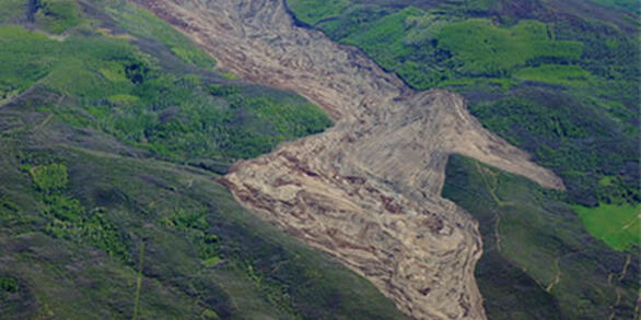
, as well as the Geomagnetism Program staff.
News
USGS Awards a Dozen Landslide Risk Reduction Grants to Enhance Public Safety and Hazard Preparedness Nationwide
USGS Research Links Weather Extremes to Coastal Sediment Supply in California
Even small lakes can tell big earthquake stories in the Yellowstone region
Publications
Estimating earthquake source depth using teleseismic broadband waveform modeling at the USGS National Earthquake Information Center Estimating earthquake source depth using teleseismic broadband waveform modeling at the USGS National Earthquake Information Center
The U.S. Geologic Survey National Earthquake Information Center (NEIC) monitors global seismicity, producing a catalog of earthquake source parameters in near-real-time to provide information that can help mitigate the societal impact of earthquakes. The NEIC commonly relies on teleseismic observations to constrain earthquake source parameters (e.g., location, depth, magnitude, and...
2024 Surprise Inlet landslides: Insights from a prototype landslide‐triggered tsunami monitoring system in Prince William Sound, Alaska 2024 Surprise Inlet landslides: Insights from a prototype landslide‐triggered tsunami monitoring system in Prince William Sound, Alaska
Alaska's coastal communities face growing landslide hazards owing to glacier retreat and extreme weather intensified by the warming climate, yet hazard monitoring remains challenging. As part of ongoing experimental monitoring in Prince William Sound, we detected three large landslides (0.5–2.3 M m3) at Surprise Inlet on 20 September 2024, within the span of an hour. These events were...
Quantitative evaluations of earthquake early warning performance using “Did You Feel It?” and post-alert surveys Quantitative evaluations of earthquake early warning performance using “Did You Feel It?” and post-alert surveys
We examine responses to the U.S. Geological Survey’s “Did You Feel It?” (DYFI) survey and its companion earthquake early warning (EEW) questionnaire to assess the performance of the U.S. ShakeAlert EEW system directly from the alert recipients’ perspectives. ShakeAlert rapidly detects earthquakes and develops alert information, but as official alert delivery partners issue these alerts...