
Nadine G Reitman, PhD
As an earthquake geologist, I use numerical modeling, field observations, and remote sensing to investigate the earthquake history and behavior of active faults, as well as how earthquake history is recorded in the landscape.
Professional Experience
Research Geologist, USGS, 2020-Present
Geologist, USGS, 2014-2016
Physical Science Technician, Denali National Park, 2010, 2011, 2013
Education and Certifications
PhD, University of Colorado Boulder, 2016-2020
MS, University of Colorado Boulder, 2011-2013
BA, Vassar College, 2006-2010
Science and Products
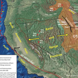
How Big and How Frequent Are Earthquakes on the Wasatch Fault?
Datasets documenting Timescales of surface faulting preservation in low-strain intraplate regions from landscape evolution modeling and the geomorphic and historical record Datasets documenting Timescales of surface faulting preservation in low-strain intraplate regions from landscape evolution modeling and the geomorphic and historical record
Digital Surface Model of the Lost River Fault, Idaho, from 1966 Aerial Photographs Digital Surface Model of the Lost River Fault, Idaho, from 1966 Aerial Photographs
Computational notebook to plot offset measurements along strike-slip faults Computational notebook to plot offset measurements along strike-slip faults
Earthquake geology inputs for the National Seismic Hazard Model (NSHM) 2023 (central and eastern United States), version 1.0 Earthquake geology inputs for the National Seismic Hazard Model (NSHM) 2023 (central and eastern United States), version 1.0
Earthquake geology inputs for the National Seismic Hazard Model (NSHM) 2025 (Puerto Rico and U.S. Virgin Islands), version 1.0 Earthquake geology inputs for the National Seismic Hazard Model (NSHM) 2025 (Puerto Rico and U.S. Virgin Islands), version 1.0
Quaternary fault mapping of the Zapata and Blanca sections of the Sangre de Cristo fault zone from high-resolution 3DEP topography Quaternary fault mapping of the Zapata and Blanca sections of the Sangre de Cristo fault zone from high-resolution 3DEP topography
UAV imagery and digital elevation data for the debris slide in Chaos Canyon, 28 June 2022, Rocky Mountain National Park, Colorado. UAV imagery and digital elevation data for the debris slide in Chaos Canyon, 28 June 2022, Rocky Mountain National Park, Colorado.
Fault Rupture Mapping of the 6 February 2023 Kahramanmaraş, Türkiye, Earthquake Sequence from Satellite Data (ver. 1.1, February 2024) Fault Rupture Mapping of the 6 February 2023 Kahramanmaraş, Türkiye, Earthquake Sequence from Satellite Data (ver. 1.1, February 2024)
Western U.S. geologic deformation model for use in the U.S. National Seismic Hazard Model 2023, version 1.0 Western U.S. geologic deformation model for use in the U.S. National Seismic Hazard Model 2023, version 1.0
Strike-slip in transtension: Complex crustal architecture of the Warm Springs Valley fault zone, northern Walker Lane Strike-slip in transtension: Complex crustal architecture of the Warm Springs Valley fault zone, northern Walker Lane
Compilation of offset measurements and fault data for global strike-slip faults with multiple earthquakes Compilation of offset measurements and fault data for global strike-slip faults with multiple earthquakes
Plotting multiple fault representations: Applications for National Seismic Hazard Model 2023 update (NSHM-faultmaps) Plotting multiple fault representations: Applications for National Seismic Hazard Model 2023 update (NSHM-faultmaps)
Timescales of surface faulting preservation in low-strain intraplate regions from landscape evolution modeling and the geomorphic and historical record Timescales of surface faulting preservation in low-strain intraplate regions from landscape evolution modeling and the geomorphic and historical record
Limited preservation of strike-slip surface displacement in the geomorphic record Limited preservation of strike-slip surface displacement in the geomorphic record
Geologic input databases for the 2025 Puerto Rico – U.S. Virgin Islands National Seismic Hazard Model update: Crustal faults component Geologic input databases for the 2025 Puerto Rico – U.S. Virgin Islands National Seismic Hazard Model update: Crustal faults component
Unlearning Racism in Geoscience (URGE): Summary of U.S. Geological Survey URGE pod deliverables Unlearning Racism in Geoscience (URGE): Summary of U.S. Geological Survey URGE pod deliverables
Rapid surface rupture mapping from satellite data: The 2023 Kahramanmaraş, Turkey (Türkiye), earthquake sequence Rapid surface rupture mapping from satellite data: The 2023 Kahramanmaraş, Turkey (Türkiye), earthquake sequence
Rapid characterization of the February 2023 Kahramanmaraş, Turkey, earthquake sequence Rapid characterization of the February 2023 Kahramanmaraş, Turkey, earthquake sequence
Climatic influence on the expression of strike-slip faulting Climatic influence on the expression of strike-slip faulting
Revised earthquake geology inputs for the central and eastern United States and southeast Canada for the 2023 National Seismic Hazard Model Revised earthquake geology inputs for the central and eastern United States and southeast Canada for the 2023 National Seismic Hazard Model
Western U.S. geologic deformation model for use in the U.S. National Seismic Hazard Model 2023 Western U.S. geologic deformation model for use in the U.S. National Seismic Hazard Model 2023
How similar was the 1983 Mw 6.9 Borah Peak earthquake rupture to its surface-faulting predecessors along the northern Lost River fault zone (Idaho, USA)? How similar was the 1983 Mw 6.9 Borah Peak earthquake rupture to its surface-faulting predecessors along the northern Lost River fault zone (Idaho, USA)?
Geophysical constraints on the crustal architecture of the transtensional Warm Springs Valley fault zone, northern Walker Lane, western Nevada, USA Geophysical constraints on the crustal architecture of the transtensional Warm Springs Valley fault zone, northern Walker Lane, western Nevada, USA
The influence of frost weathering on the debris flow sediment supply in an alpine basin The influence of frost weathering on the debris flow sediment supply in an alpine basin
Non-USGS Publications**
**Disclaimer: The views expressed in Non-USGS publications are those of the author and do not represent the views of the USGS, Department of the Interior, or the U.S. Government.
Science and Products
How Big and How Frequent Are Earthquakes on the Wasatch Fault?
Datasets documenting Timescales of surface faulting preservation in low-strain intraplate regions from landscape evolution modeling and the geomorphic and historical record Datasets documenting Timescales of surface faulting preservation in low-strain intraplate regions from landscape evolution modeling and the geomorphic and historical record
Digital Surface Model of the Lost River Fault, Idaho, from 1966 Aerial Photographs Digital Surface Model of the Lost River Fault, Idaho, from 1966 Aerial Photographs
Computational notebook to plot offset measurements along strike-slip faults Computational notebook to plot offset measurements along strike-slip faults
Earthquake geology inputs for the National Seismic Hazard Model (NSHM) 2023 (central and eastern United States), version 1.0 Earthquake geology inputs for the National Seismic Hazard Model (NSHM) 2023 (central and eastern United States), version 1.0
Earthquake geology inputs for the National Seismic Hazard Model (NSHM) 2025 (Puerto Rico and U.S. Virgin Islands), version 1.0 Earthquake geology inputs for the National Seismic Hazard Model (NSHM) 2025 (Puerto Rico and U.S. Virgin Islands), version 1.0
Quaternary fault mapping of the Zapata and Blanca sections of the Sangre de Cristo fault zone from high-resolution 3DEP topography Quaternary fault mapping of the Zapata and Blanca sections of the Sangre de Cristo fault zone from high-resolution 3DEP topography
UAV imagery and digital elevation data for the debris slide in Chaos Canyon, 28 June 2022, Rocky Mountain National Park, Colorado. UAV imagery and digital elevation data for the debris slide in Chaos Canyon, 28 June 2022, Rocky Mountain National Park, Colorado.
Fault Rupture Mapping of the 6 February 2023 Kahramanmaraş, Türkiye, Earthquake Sequence from Satellite Data (ver. 1.1, February 2024) Fault Rupture Mapping of the 6 February 2023 Kahramanmaraş, Türkiye, Earthquake Sequence from Satellite Data (ver. 1.1, February 2024)
Western U.S. geologic deformation model for use in the U.S. National Seismic Hazard Model 2023, version 1.0 Western U.S. geologic deformation model for use in the U.S. National Seismic Hazard Model 2023, version 1.0
Strike-slip in transtension: Complex crustal architecture of the Warm Springs Valley fault zone, northern Walker Lane Strike-slip in transtension: Complex crustal architecture of the Warm Springs Valley fault zone, northern Walker Lane
Compilation of offset measurements and fault data for global strike-slip faults with multiple earthquakes Compilation of offset measurements and fault data for global strike-slip faults with multiple earthquakes
Plotting multiple fault representations: Applications for National Seismic Hazard Model 2023 update (NSHM-faultmaps) Plotting multiple fault representations: Applications for National Seismic Hazard Model 2023 update (NSHM-faultmaps)
Timescales of surface faulting preservation in low-strain intraplate regions from landscape evolution modeling and the geomorphic and historical record Timescales of surface faulting preservation in low-strain intraplate regions from landscape evolution modeling and the geomorphic and historical record
Limited preservation of strike-slip surface displacement in the geomorphic record Limited preservation of strike-slip surface displacement in the geomorphic record
Geologic input databases for the 2025 Puerto Rico – U.S. Virgin Islands National Seismic Hazard Model update: Crustal faults component Geologic input databases for the 2025 Puerto Rico – U.S. Virgin Islands National Seismic Hazard Model update: Crustal faults component
Unlearning Racism in Geoscience (URGE): Summary of U.S. Geological Survey URGE pod deliverables Unlearning Racism in Geoscience (URGE): Summary of U.S. Geological Survey URGE pod deliverables
Rapid surface rupture mapping from satellite data: The 2023 Kahramanmaraş, Turkey (Türkiye), earthquake sequence Rapid surface rupture mapping from satellite data: The 2023 Kahramanmaraş, Turkey (Türkiye), earthquake sequence
Rapid characterization of the February 2023 Kahramanmaraş, Turkey, earthquake sequence Rapid characterization of the February 2023 Kahramanmaraş, Turkey, earthquake sequence
Climatic influence on the expression of strike-slip faulting Climatic influence on the expression of strike-slip faulting
Revised earthquake geology inputs for the central and eastern United States and southeast Canada for the 2023 National Seismic Hazard Model Revised earthquake geology inputs for the central and eastern United States and southeast Canada for the 2023 National Seismic Hazard Model
Western U.S. geologic deformation model for use in the U.S. National Seismic Hazard Model 2023 Western U.S. geologic deformation model for use in the U.S. National Seismic Hazard Model 2023
How similar was the 1983 Mw 6.9 Borah Peak earthquake rupture to its surface-faulting predecessors along the northern Lost River fault zone (Idaho, USA)? How similar was the 1983 Mw 6.9 Borah Peak earthquake rupture to its surface-faulting predecessors along the northern Lost River fault zone (Idaho, USA)?
Geophysical constraints on the crustal architecture of the transtensional Warm Springs Valley fault zone, northern Walker Lane, western Nevada, USA Geophysical constraints on the crustal architecture of the transtensional Warm Springs Valley fault zone, northern Walker Lane, western Nevada, USA
The influence of frost weathering on the debris flow sediment supply in an alpine basin The influence of frost weathering on the debris flow sediment supply in an alpine basin
Non-USGS Publications**
**Disclaimer: The views expressed in Non-USGS publications are those of the author and do not represent the views of the USGS, Department of the Interior, or the U.S. Government.